For as long as I can remember, I have had a Robinson Crusoe/Swiss Family Robinson fantasy of living on a tropical island. Well, I finally got my wish - with a lot more comforts than in either of those stories!
Matthew Kosnick, a colleague of Darrell's, studies the marine ecosystem of the Great Barrier Reef (GBR). He does both paleoecology (Darrell has analyzed some of Matthew's past shell collections at his laboratory at NAU) and modern ecology and can then make some comparisons between the past and present. Matthew made arrangements for Darrell and I to join his research team at One Tree Island (OTI) in the southern part of the GBR in early May. Yahoo!
We met Matthew, his friend and fellow scientist Erin, his graduate student Julietta, and her roommate and fellow marine graduate student Marcela, at the Heron Island ferry terminal on May 7th. All the people and materials for OTI go to the larger and more accessible Heron Island first. The reef system around OTI makes it impassable for boats except during the highest tides, so shucks, you could easily get stranded on the island for ten days or so...
 |
| Julietta and Marcela on the ferry to Heron Island |
We left from Gladstone Harbor, one of the busier ports in Australia, where many ships loaded with Australian coal head to China each day.
 |
| Aussie coal to be burned in China |
Heron Island is 72 km from the mainland. The wreck sitting
on the reef crest of Heron Island is the HMCS Protector. This is Australia’s
first naval vessel and is the only Aussie-owned vessel to have served in three
wars. It was enroute to service in 1943 when it was damaged and abandoned on a
Gladstone Beach. The owner of the Heron Island Resort at that time bought it for
10 pounds and transported it to Heron Island to serve as a breakwater for small
craft visiting the island.
 |
| The HMS Protector - still reporting for duty |
Heron Island has a tourist resort on one-fourth of it, the University of Queensland's
Heron Island Research Station (since 1951) on one-fourth and the other half is Capricornia Cays National Park. The island is bisected by the Tropic of Capricorn.
This satellite image below is of Heron Island and I will use it to explain the body parts of a Paramecium, I mean - the working structure of a barrier reef!
 |
| Satellite image of Heron Island and its reef system |
The actual island is the darker red oval on the far left. For all you biologists it reminds me of the macronucleus of a Paramecium. The oral groove (I mean blue water channel) is dug through the reef and goes from the reef edge on the far left of the island. The black surrounding the Paramecium is the deeper ocean, and the red-brown outline (pellicle) is the outer reef. The beautiful blue interior is the inner lagoon. At low tide some of the sandy colors would be exposed, but normally everything except the island would be underwater. You can see why you need a channel to reach the island as the coral is close to the surface in most places, and especially along the outer reef. The isolated coral "bumps" in the inner lagoon are called "bommies".
The Heron Island Research Station has both an educational and a research function. They have classrooms, dormitories, and a cafeteria for large school groups that come through. They also have active research programs, including a large CO
2 monitoring program to determine how coral reefs may respond to different levels of atmospheric CO
2. The ocean presently absorbs a lot of the additional CO
2
we pump into the atmosphere and is already showing signs of acidification because of this. Fortunately, the GBR has a decent buffering system because of all the carbonate sediments, but the effects of increased acidification haven't been well studied yet.
 |
| Carbon dioxide experiment at Heron Island Research Station |
Darrell and I walked around Heron Island and then we all met for cocktails and to watch the sunset from the resort.
 |
| Sunset reflected behind Matthew, Erin, and Peter at Heron Island Resort |
 |
| Sunset on Heron Island |
The next morning we loaded all our gear on the Linckia II, and Peter captained us to One Tree Island. The trickiest part is getting over the outer reef without hitting any of the coral. You can see the edge of the boat, the coral just below it, and One Tree Island in the distance.
 |
| Crossing the outer reef can only be done on the highest tides... |
You can see the fine green line of the island in the picture above. Then we get a little closer and you can see the station with its solar panels on the roof, and the shop area to the right of it, and then the wet lab with the large white salt water tanks above it.
 |
| First view of One Tree Island station |
Our first job was to unload the boat.
 |
| Pete anchoring the boat so we can unload |
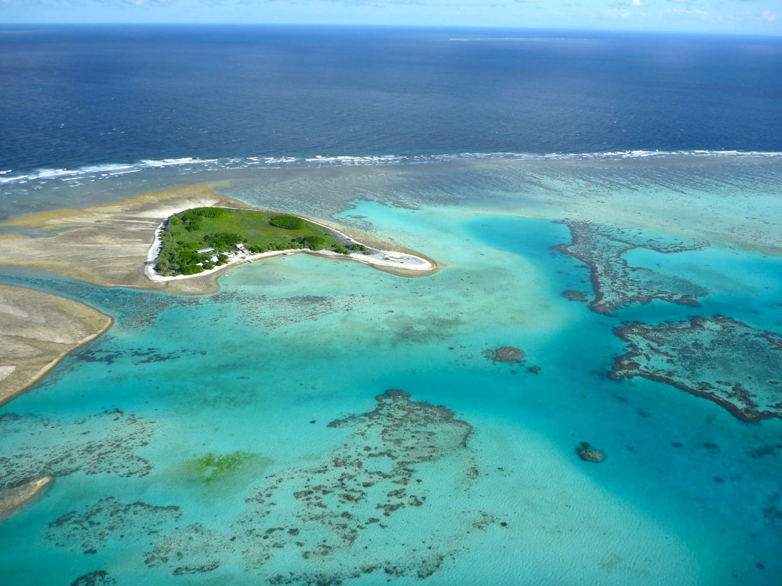
One Tree Island's lagoon system has a similar structure to that of Heron Island (and much of the GBR). Darrell took this photo from the helicopter when he left One Tree to return to the mainland. Poor guy had to leave early to attend a meeting in Switzerland while I stayed on the island with the research team. You can see the station facing the calm lagoon, with the outer reef on the back side of the island. Most of the island is a reserve (part of Capricornia Cays National Park) so we could only walk on the station grounds and between high and low tide around the island.
 |
| One Tree Island, 10 acres of paradise |
Next post - life in paradise!


No comments:
Post a Comment