Friday, January 20, 2012

Raglan to Wanganui

December 28th- January 4th
We had a lonely drive south on Hwy 1 after waving goodbye to Lindsey at the Auckland airport (see last post). Our destination was now Raglan, a surfer town on the west coast.  Since most locals and many tourists head to the white, sandy beaches of the east coast, we went west.  Raglan had a large tidal flat, so along with surfers, there were many kite-surfers and fisherman – all in the best places for their sport along the coast. The local i-sites (information centers) are the best places to get clued in to camping spots that aren’t necessarily on the map. We learned about a private campground near the beach that was land that had been taken from the Maori many years before and was now recently returned.  The golf course reverted to grassland and we got a prime place to camp for $10.  I went for a long walk along the beach while Darrell worked, and then he went for a run on the beach while I hand washed some clothes and even washed the van. Living in a small space, it is critical to give each other some alone time!

UFO being used as a home in Raglan
We use the car battery to recharge our computers, and we didn’t know then how quickly we drained our battery with the inverter, so the next morning we had to get a jump from one of the guys at the camp.  Later we bought our own jumper cables so we could charge the car battery off the auxiliary battery if we ran it down too far!

Raglan was pretty hip and nice, but we moved one beach town farther south to Kawhia which promised to be even more laid back.  Kawhia is one of the places where there was a historic canoe landing (usually considered to be in the 14th century) and it remains a town with a sizeable Maori population. We stayed at what is known as a POP (Park Over Property) where, for a minimal fee (free to $10) you can stay on someone’s private property, but they rarely have any amenities.  So you need to be “self-contained” since there is no potty, showers, etc. We had a lovely tidal river view though so we stayed two days.  I walked into town and used the public toilet since it was so close. I am not mentally prepared to clean a port-a-potty so we haven’t used it yet!  Thank goodness NZ has many nice public restrooms!

Entrance to Kawhia town and harbor
Kawhia also has a hot water tidal beach like we found on the Coromandel Peninsula but it was much less crowded!  We couldn’t find a great hot spot though and it was raining, so we didn’t last too long in the tepid water.

We wound our way out of Kawhia, returning to the highway; a relief after driving narrow, windy roads with few guardrails and many drop offs… On the way south we cruised through Otorohanga, whose main road has Kiwiana signs hanging on both sides.  Kind of silly, but whatever lures in tourists helps the bottom line! See if you can spot the kiwi fruit, fern (symbol of the All Blacks national rugby team), sheep, jandals (Japanese sandals) and then my eyes can't focus any farther!

Kiwiana symbols line the street in Otorohanga
We checked out some interesting rock formations near Te Kuiti and then stopped to see some amazing driftwood sculptures at Wade’s Landing near Raurimu.  They are amazing!

Darrell dwarfed by the Giant Moa
Our next detour took us along the incredible Wanganui River. Darrell ogled the huge, bedded Quaternary (last 2 million years) deposits along the road to Pipiriki (don’t you love these names?)  and then along the Wanganui River Road.

We spent New Year’s Eve at the quietest campsite I’ve ever been at.  There was one other couple besides ourselves.  The ground was so soggy from all the rain that it was like walking across a sponge! The other couple was there for a family gathering at the local marae.  A marae, as I understand it, is the tribe's community center where all important group decisions and celebrations take place.

Marae along the Wanganui River
The next morning, we had more Kiwi-road adventures. Small landslides blocked some areas and hadn't been cleared yet - it was New Year's Day after all!

Rain plus steep hills equals landslides
The deposits along the road made it interesting in other ways also! There is a giant fossil oyster bed in one of the deposits. Darrell is at the bottom of the exposure in the picture below.

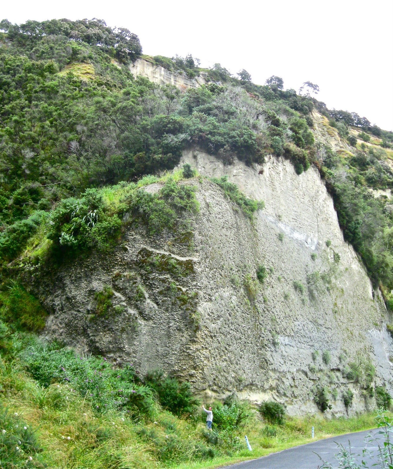
Darrell (tiny dot above) and the giant oyster bed
As the river valley widened out, we saw signs of civilization again. Besides omnipresent cows and sheep, there are many tree farms. You can drive a long time between wild places, especially if you don't get off the main roads...

Nature doesn't usually grow trees in rows!
At the end of the river, we came to Wanganui - which turned into one of our favorite places. At the friendly i-site we could surf the internet and charge our computers at the same time! You don’t know how exciting this is! Plus Darrell had some interesting geology to do, so we tramped up and down long beaches collecting shells from different glacial stages represented in the cliff sediments. We camped in three different places over four nights and actually felt like we were getting to know the town by the time we left!

Geology on the beach - life is good!
The van was ready for its 90 km check up, so we drove to the VW dealer in Palmerston North and walked from there to downtown.  We spent the afternoon at a local cafĂ© and then at the library where we were introduced to the lovely Aotearoa People’s Network – a free wifi service at many libraries in New Zealand.  This is a true gift to travelers. (Which I am using now!)

Last note: Oil changes in NZ are like in Australia – you pay closer to $300 than the $30 we pay at home.  I haven’t figured that why. Thankfully, the dealer we bought the van from also included our first oil change so they paid the bill. And, while gas is a little over $6/gallon, car insurance is incredibly cheap. There are limits on suing over car accidents so our “high” rate as Americans who drive on the other side of the road, was $347 for the entire year! Isn’t that what folks pay for a week in LA?

Taranaki Peninsula to the North!

December 22nd – 28th
After our lovely walk to Taranaki Falls (see previous post for the 1st NZ installment) we wound our way (literally) over hill and dale on the Forgotten World Highway which we are still trying to forget. It looked like the shortest path between where we were and where we wanted to go, but it was a torturously slow, narrow, winding, pasture-filled road with a few good viewpoints.

Looking back on Ruapehu (2797 m) from one of the viewpoints.
Near the middle of this land of sheep and cows is the Republic of Whangamomona. Every place needs its schtich if they are going to get you to drop your coins there, and this one has a doozy.
The story goes that in 1989 the government was shifting boundaries and the small town of Whangamomona (population 105) would been moved to their rival rugby team’s area, so they declared themselves a Republic. For $5 you can get a passport from the Republic, or for just $1 you can get a stamp in your own passport.  Since I like to support the harmless wacko’s in the world, I now have a stamp!

Mindy in Whangamomona
Near the end of the longest 150 km of my life, we got a nice view of Mt. Taranaki.  This gorgeous stratovolcano forms the center of the Taranaki Peninsula on the west side of the North Island.

Mt. Taranaki
Lindsey had friends recommend the beach side campground at Oakura and we got a beautiful site right next to the beach.

Lindsey on the beach at Oakura.

Sunset at Oakura Campground
We took an evening stroll through the New Plymouth botanic garden, decked out in lights for the holidays, and then woke up to sunshine on the beach the next morning. The campground even came with a morning visit from friendly ducks.

Friendly and lame duck at Oakura
The following day took us on a hunt for the “Three Sisters”, rock formations off the coast north of the peninsula.  We finally got close to them, but slippery rocks sent me into the mud and we didn’t complete the low tide walk out to see them. We headed instead to Waitomo Caves where we took a tour that culminated in a silent boat ride to see glowworms. These interesting creatures cling to the cave ceiling and use light to attract prey. From our vantage gliding below, they were constellations of twinkling green.

We had a long drive ahead of us to get to the holiday house we rented for Christmas, so we drove close to Auckland, camped for the night, then got on the road early to the top end of the North Island. We made a potty stop in Kawakawa where there is the grooviest public restroom I’ve ever seen. Created by the Austrian artist Friedensreich Hundertwasser, it features bright colors, wavy lines and a roof with wild grasses.  Hundertwasser, who has work in Japan and Europe as well, lived in a remote home here for the last 27 years of his life.

Hundertwasser Public Restroom in Kawakawa
We had booked our holiday house when we were with Rick and Nancy in Prague, becoming nervous that we wouldn’t find a place if we waited too long. The summer holiday in the southern hemisphere is from before Christmas to the end of January, so many New Zealanders are also traveling with their families then and the prime spots, especially along the beaches, fill up fast!

"Our" beach house is in the back left of photo
Most of the time at Cable Beach we looked like the picture below as we helped Lindsey with her hunt for tiny opercula. Opercula are the “trap doors” of snails that close when they tuck their soft parts back in. They are more resistant to weathering than other parts of the snail shell, so you find them midst the sand and other bits of broken shells along the beach. The opercula on Cable Beach were lovely, pearly and round, and we spent some time helping Lindsey with her collection.

Lindsey and Mindy and the great opercula hunt
We had a warm Christmas day walk on Mahinepua Peninsula and then enjoyed a lovely roast chicken dinner. Our first and last use of an oven since we’ve arrived!

Our Holiday Card for 2011!
The next day we drove to 90-mile beach.  The wind was blowing, and the sand was on the move, so we didn’t stay long. Instead we went to the Gumdiggers Museum and walked the winding trail between holes where the kauri gum workers, from the 1870’s to the 1920’s, had dug out the pitch from ancient buried kauri trees to sell for making varnish and linoleum. Kauri, almost as big as  redwoods, used to cover this area for 100,000 years, but is now rare. The Maori used a few for their dugout canoes, but the newer immigrants forested most of it for timber.  There are kauri reintroduction efforts now and we saw some young kauri growing amongst the ancient dead.

Gumdiggers washing kauri gum from http://www.gumdiggerspark.co.nz/gallery.htm

On the way back down the peninsula to Auckland, we visited the Waitangi Treaty grounds, where the most important document in NZ was first written, debated, and signed. The February 6, 1840 treaty established New Zealand as a nation, under British rule of course. It was translated into Maori and many (but not all) Maori leaders from around the country signed it. The treaty was interpreted differently by Maori and Pakeha (European settlers), and resulted in massive land loss by the Maori, some of which is now being returned.  The treaty still dominates national politics; it is a living document.

Traditional canoe (waka) of kauri, built for the centenary of the Waitangi Treaty
Our last adventure before Lindsey had to fly home was in Auckland! This was the adventure of finding a parking place for a 2.7 meter tall van in a big city.  None of the parking garages were tall enough so we wandered a bit before we could find on-street parking.  We went out for tapa’s and Lindsey went to a few of her favorite clothing stores, well-remembered from our Australia days.

Christmas in Auckland!
We stayed in the crummy little Kiwi Motel by the airport as Lindsey had an early flight home the next morning.  It was hard to say goodbye to our girl… We miss her!