Friday, April 27, 2012

The Joys of Housesitting


March 28th – April 27th
After three and a half months of living in the van, we moved into Chris and Christina’s house in Dunedin. It was amazing to sleep in a bed and to have a bathroom available at any time. What a luxury! Plus, the home they are renting has a sweet yard and garden, and they are just 2 blocks from an amazing stretch of white sand and waves.

Fuchsia at Chez Moy
I took daily walks on this gorgeous beach.

View looking back to St. Clair

View to a distant island from St. Clair beach
Besides many, many hours walking along the beach, I also walked into town a few times (or rode in with Darrell when he went to work at the university) and enjoyed the architecture, the shops and the Speight’s Brewery Tour. Speight’s is the South’s largest selling beer and goes for the Marlboro man image in its sales. Remember, the south here is like the Great White North back home!

The Speight's image of the "Southern Man"
It turns out beer has a long tradition in New Zealand. The brewery tour featured a recipe from Captain Cook. I think beer was used to help prevent scurvy, but I’m sure it also helped keep the men from potential mutinies!

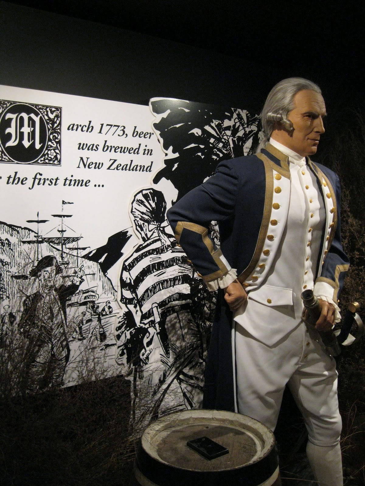
Brewmeister Captain Cook
Captain Cook has always been one of my heroes. And I have to say he does look dashing here!

Though I realize it is really kitschy, I took a picture of “the world’s steepest street”, and I can assure you, whether or not it really is the steepest, there are a LOT of steep streets in Dunedin!

The World's Steepest Street
We also happened upon a gypsy carnival and got to see some folks with much more creatively decorated vans than ours!

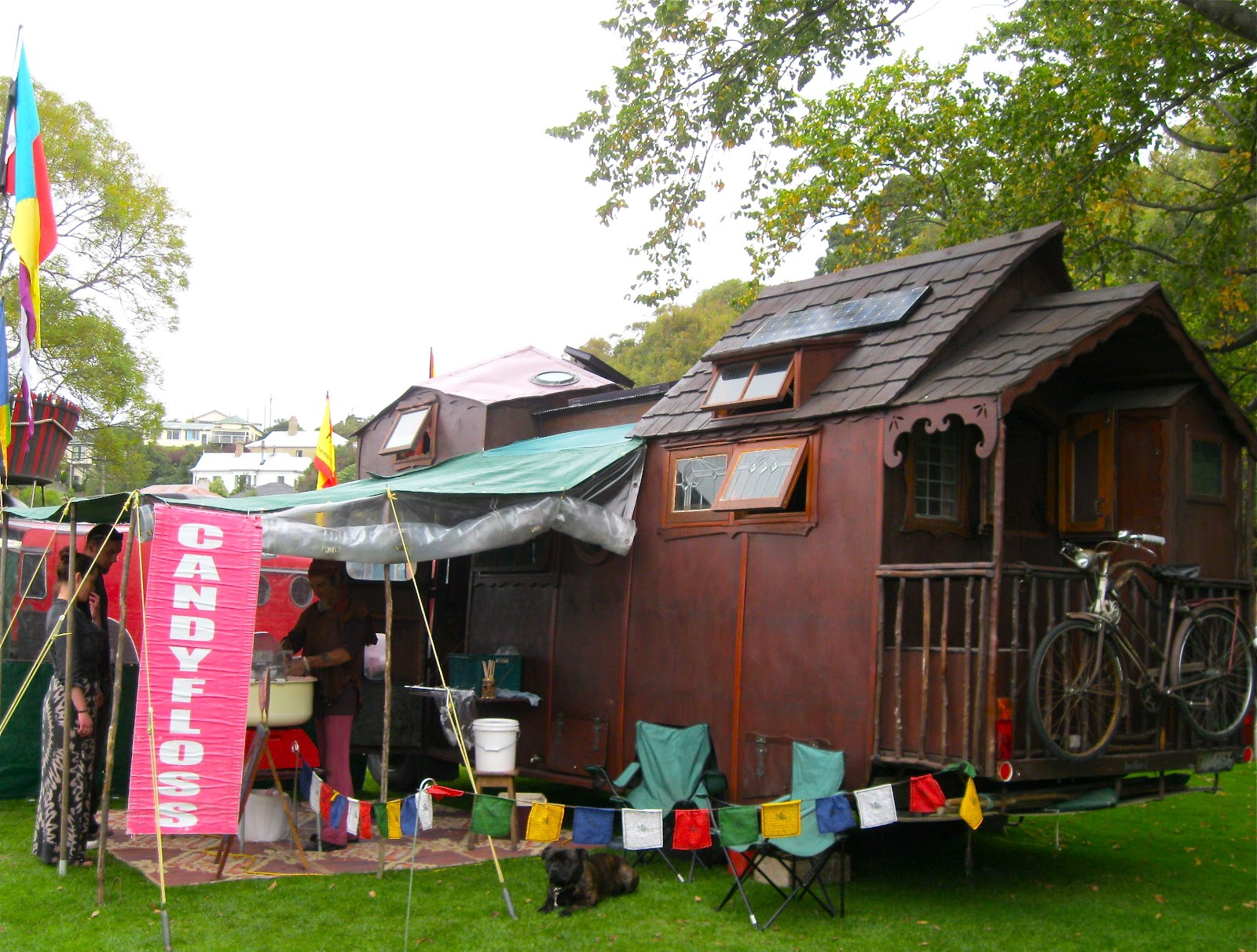
Gypsy caravan in Dunedin
As soon as we settled into the house we put our van up for sale and cleaned it all up. We had a pretty serious bite, but it didn’t pan out in the end, so after three weeks of enjoying our house-sitting in Dunedin, we headed back to Christchurch and the North Island again.

We enjoyed a wonderful Vietnamese dinner in Christchurch with Margaret (Matt was at a conference in Kansas) and then drove past Kaikoura along a gorgeous stretch of the northeast coast of the South Island that we hadn’t seen yet. Purely by accident, Darrell stopped at a viewpoint, and we had an amazing wildlife encounter. During the winter months, baby seals (not adults) hang out in Ohau Creek, even swimming upstream approximately 300 meters to play in a pool under a waterfall. It is truly AMAZING! There are about 200 NZ fur seal babies goofing around in the water and on the rocks. After a few days they go down to the coast where their mom’s find them and feed them, and then they go back up to the waterfall “nursery”. Sooooo cool!

Baby seals playing in the waterfall pool!
Way way way too darling for words!
We made one more stop to pick up our favorite Maharajah Chutney at a gift shop in Blenheim. We've been tasting chutney all around NZ, and this is worth a special stop. Come see us soon to taste it before it is all gone!

Then we caught the Saturday afternoon ferry back to Wellington and met up with Heidi and Peter at a wonderful restaurant downtown called Chow. Then they welcomed us to their homey house in the hills above Wellington. We are now house-sitting here as Heidi and Peter had to go Lake Ohau where Heidi’s research is based. (See previous post)

Our first day here we went to the top of Johnston’s Hill and got some pictures looking back to town.

View of Wellington from Johnston's Hill
Wellington is also known as “Windy Welly” and they make good use of the wind with a series of wind turbines on the hills outside of town.

Windy Welly does its bit for renewable energy
Heidi’s and Peter’s house is also near the Karori Cemetery where some famous people are buried. If you are an Antarctic history fan you will have heard of Harry McNeish and his famous cat Mrs. Chippy. While the cat never made it back from Antarctica, Harry did – and now the likeness of Mrs. Chippy resides on his grave.

Harry McNeish and his wonder-cat, Mrs. Chippy
It turns out Mrs. Chippy was really a male cat, but sometimes it is hard to change your name!

Thursday, April 26, 2012

Rocking geology and some geologic wonders!


March 15th – 28th
We stayed at South Brighton Beach Holiday Park for five days – where Darrell could work and I could walk on the beach and go to the library where there is free wifi and a spectacular view of the ocean.  We also had Maria over for chicken fajitas (definitely our “signature” meal of the NZ sabbatical) and she made brownies for us. She is now off sailing in New Caledonia but I’m sure, someday, we will bump into her again!

On the 19th we returned to Waipara, just north of Christchurch, and collected samples at the incredible loess exposure we had seen earlier. Our reward after a day of climbing up and down the steep silt cut was a Pinot Noir tasting at Mudhouse Winery. Lovely wines, and we also learned about the council campground at Amberley Beach. Council campgrounds are fantastic as they are usually in nice, uncrowded places, and are inexpensive.

The next morning I sieved the silt and shells Darrell had collected (just call me geology slave) and then we headed to the other huge cliff exposure at Glenafrick Station and collected more shells. This is a 90-meter cliff exposure, but thankfully there was a slump at the top so we could work where falling wouldn’t be fatal.

90 meter drop to the ocean!
That night we camped at Waipara Sleepers where there are old converted train cars, and the camp owner prepared bread each night to pop out of the bread oven at 8 am! Plus there were fragrant flowers and hedges to divide the sites that really enhanced the normal campground ambience.

Being a complete hot spring junkie I convinced Darrell to drive to Hamner Hot Springs, a small resort town with a developed hydrothermal area. The drive itself was one of the nicest we’ve been on, winding along a river valley with spectacular terraces and nice autumn colors.

And the hot spring complex was amazing. Though of course I love natural undeveloped hot springs the best, these were quite tastefully done. Plus there were three aquatherapy pools with a variety of jets, waterfalls, showers, etc. so you could focus on almost any muscles you wanted to with a jet blast or something more gentle. I alternated between just soaking in the 42 degree C (almost 108 F) pool and then getting massaged under waterfalls in the aquatherapy pools where the water was the same temperature as your body. You literally couldn’t tell where your body ended and the water began. Heaven.

Google image of one of the aquatherapy pools
We camped one night near the pools so I could enjoy them again in the morning, and then the second night we camped at a DOC site by the river near Lewis Pass. The pass itself was shrouded in rain and clouds so we didn’t have good visibility, but camping by a river is always a treat.

As soon as we descended from Lewis Pass we were back in the sun. On the way south we stopped in the small town of Geraldine where I bought myself some birthday presents at the farmer’s market; good cheese, some possum-merino blend wool, and a little purse. I may not be into shoes, but I definitely have a bag fetish…

From there we continued on to Twizel (for the third time!) and found Heidi Roop and her new colleagues from GNS and the University of Victoria in Wellington. GNS (originally the Institute of Geological and Nuclear Sciences) has been around since 1865. Considering New Zealand straddles two tectonic plates (earthquakes anyone?) and was the home of Ernest Rutherford, they have a long and successful history in science.  Their Māori name is Te Pū Ao, which means “the foundation, origin, and source of the world”. Cool name, eh?

Heidi is beginning her PhD with a project based on understanding more about the glacial geology and sedimentation at Lake Ohau. She could tell you a lot more about it!

Heidi is excited to begin her PhD!
This area around the big lakes (Tekapo, Pukaki, and Ohau) reminds us some of Wyoming. See what you think of the view framed by the wooden fence.

Twizel "Wyoming"
When they damned the river near Twizel for the beginning of a series of hydroelectric dams, they formed a large lake that is now used for national canoe and rowing races. It was too windy for the races when I was there, but there were over 40 team tents set up for the South Island competition!

Racing lake to the left and team tents to the right.
Darrell took the day off for my birthday (I take every day off) and we had a great hike on the South Branch trail off Lake Ohau. We had to cross some huge talus fans on the trail.

Darrell crossing one of many talus fans
After three hours of hiking, we reached the hut and a view of one of the melting glaciers sending water to the Lake.

South Branch hut and glacier
We didn't stay at the hut, so walked back across the talus fans and crossed the river to our van. You can barely see our white dot of a van in the middle of the landscape as we returned from the hike!

Lost in the landscape
We camped at the trailhead, and the next morning drove to the Clay Cliffs that we also read about in the NZ Frenzy book. These crazy pinnacles formed after 2 million years of erosion along an active fault line.

Darrell in the shadow of the clay cliffs
Our last stop before we met up with Chris again in Dunedin was a campground in Hampden, just north of the Moeraki boulders.  In fact, you can walk all the way along the beach to the boulders, so I was able to get this sunrise view. Some people end with sunsets, but I'll end with this!

Moeraki sunrise

Super dooper secret places on the way to Christchurch


March 11th – 15th
 Darrell, Vera and I enjoyed a nice morning with Chris and then said our goodbyes and headed north. Our first stop was a “secret” place revealed in Scott Cook’s NZ Frenzy guide. The explicit directions delivered us to an almost hidden trail. It was raining and we literally slid to the coast, but oh the rewards!

Vera at the Mermaid's Bath!
It would have been so awesome if it was hot and sunny as the rocks, exposed at low tide, were Mermaid’s baths!

Birthplace of the concretions!
Another egg being hatched!
Some of these 70-million year old concretions yielded important fossils including this plesiosaur that I later took a photo of at the Otago Museum.

Plesiosaur from Kapiti Beach formation
We may not have seen any plesiosaurs when we were there, but you can imagine some of the concretions could hold large fossils - or mermaids...

Another awesome tide pool bathtub!
We continued along this road to Kapiti Point where there was a bird blind so you could watch the resident Yellow-eyed penguins. There were penguins there even during the day but were far away and required binoculars to see well from the blind. Once again though, NZ Frenzy told us what trail to take to get an up-close-and-personal view of the penguins. A couple that lived here had taken in some injured penguins and really improved the habitat including building penguin “nests”. There is now a fairly large population, somewhat used to people, that make this area their home. Amazing!

Yellow-eyed penguin!
There were also seals and sea lions and lots of shags (cormorants). Great spot!

It rained off and on all day and was raining when we camped at Trotter’s Gorge, a DOC site nearby. Vera and Darrell had the brilliant idea of setting up the tent inside of the van so we could put it up dry. I could not imagine this as the van is NOT that big, but it actually worked! We even had the fly over the tent before we set it up outside.

The next morning we saw the sun again so Vera and I walked up the slippery mud trail and did a circle tour of the gorge area. Then we headed to Moeraki Boulders just a bit farther north on the coast and part of the same formation as the Mermaid’s Pools we had seen the day before.  These boulders are well known though and draw many tourists.

Darrell and Vera watching the turtles, aka Moeraki Boulders
The boulders have happy mussels at high tide and
 happy people at low tide!
After a brief walking tour of the historic town of Oamaru, complete with women wearing clothes from the 1800’s, we continued on to a fishermen’s campground at Rakaia Huts along the coast. It was loaded with men and fishing poles, since it was at the mouth of a large river. It was our last night camping with just the three of us…

The next morning we drove to the Banks Peninsula, named by Captain James Cook for his naturalist Joseph Banks in 1770. This peninsula formed from two volcanic eruptions and there are numerous harbors in the steeply incised coast.

I just discovered an image of the Banks Peninsula taken from the Space Station!

Christchurch is to the right, Akaroa is in the center of the peninsula
Akaroa, the main town, is on the largest harbor and has a Mediterranean feel. Cruise ship passengers wander the once-French town and even Vera and I got in the shopping spirit here. We also took a hike up to a peak, getting great views of the area.

Pretty garden and cottage in lovely Akaroa
Akaroa beach and harbor
The Banks Peninsula is just southeast of Christchurch so we arrived at Matt and Margaret’s house in time for Mutton Stew and the accompanying great dinner conversation! Vera and Matt are long-time colleagues and had lots to catch up on. The next day, Matt took Vera and I back up Arthur’s Pass into the mountains. Matt wanted to refamiliarize Vera with some of the NZ plants so he took us to a variety of habitats. Vera has done a lot of work in Chile and Argentina so some of the plants are the same or similar, but New Zealand has an ENORMOUS number of endemic species. According to the Wellington Botanic Garden, roughly 85% of NZ’s 2,300 species of “higher plants” (who needs mosses anyway?) are endemic!

Vera and Matt looking out over Arthur's Pass
The next day, March 15th, was Vera’s last day in New Zealand. We took the bus downtown and then walked through the Christchurch Botanic Garden and back to Matt’s and Margaret’s to gather her bags. It was lonely saying goodbye to Vera after our 3 great weeks together. And then we skyped with Lindsey, for her 20th birthday, and I got even more homesick. It didn’t help that it was gray and cloudy...

So I don’t end on a down note - it did get sunny the next day, and we settled ourselves back at South Brighton Beach Holiday Park and slowly got back in the groove of just the two of us. We even saw Maria, our wandering friend from Spain, and she made us brownies. Sunshine, chocolate and friends are all good ways to beat the blues!

Wednesday, April 18, 2012

Dunedin and the Otago Peninsula

March 9 – 11th

After leaving our great campsite, we walked to Purakaunui Falls - the prettiest falls in the Catlins from the ones we saw!

Purakaunui Falls
We took the coastal road to Dunedin, and when we were still far out of town we came upon the "Welcome to Dunedin" sign. It turns out that Dunedin is the fifth largest city in the world - by geographic size! It only has 123,000 people of which 25,000 are University students, but it is definitely large in area.

This area was first settled by Maori, then whalers and sealers, before it was firmly established as a Scottish community in the mid-1800's. Dunedin is the Celtic name for Edinburgh and it is possible to find haggis here, though I am NOT tempted. It also has the largest curling rink in the Southern hemisphere.

We drove straight to the University of Otago where we met Dr. Christopher Moy. Chris, a colleague of both Darrell and Vera, is a professor here and he gave us a tour of campus as well as a driving tour of Dunedin. The University of Otago is New Zealand’s oldest university, founded in 1869. It is a lovely campus as you can see from the photo of our van in front of the clocktower.

The Clocktower with our van peaking out to the right of the tree
Walking around the University we came upon some improvised student housing.  Maybe not as nice as the tree houses at the University of Santa Cruz, but you have to take what you can get!

Prime student housing in Dunedin
The next morning, while Chris worked, Darrell, Vera and I played tourist. Our first stop was the farmer's market near the historic train station. Vera and I were entertained by the youth playing bagpipe's in the garden. Notice the giant purple tower - home of Cadbury Chocolates - behind him!

Bagpipes, British gardens, and Cadbury
We then drove out to the Otago Peninsula. First we tried to walk to Sandfly Bay, where there is a hide for watching penguins (though they are rarely there during the day). The winds were so strong the sand was blowing in our faces, so we gave up and went to the Marine Science Center on the other side of the peninsula.

Marine Science Center on the Otago Peninsula
We lucked out because it was fish-feeding day at the aquarium, so we got to see the fish (including some sharks) get a little more excited than they might normally. We also took a walk to visit more sheep. You can see the effect of the wind on the shrubs here!

Wind-swept trees and ever-present sheep
That evening Chris had a barbecue at his house and we got to meet some of his other colleagues as well as a German group that was there for research and some of the great graduate students in his department.

The next morning I got up early and went for a swim in the neighborhood salt water pool. It is so great to be swimming outdoors in HEATED water. Unfortunately, it is only open in the 6 warmer months so closed on the last day of March...

St. Clair Salt Water Pool
When I got back to the house, we all hung around the kitchen working on computers and drinking coffee. It is fun to watch scientists interact and get excited about the science they are doing.

Working in Chris's kitchen (Photo by Vera)
Chris invited us to return and house-sit while he is off at field camps and doing his own research in April, so we will be back to this lovely place again!


The Wild and Wooly Catlin Coast


March 5th – 9th
At the end of our great day on Ulva Island (see last blog), Vera and I headed to the ferry. On the way we overheard a lovely young backpacker being asked if she was on holiday, for perhaps one too many times, as she sassily replied “No, I’ve come here to die.”

While I’m sure she intended it as a flippant response, and she was far too young to be contemplating her demise, I think Stewart Island would be a lovely choice for a final resting place. If you walked slowly enough into the woods you would be wrapped and concealed by moss and fern and gently become part of the landscape…

Crossing Foveaux Strait, we were lucky enough to see some incredible seabirds. Vera saw a raft of Little Blue Penguins as they headed back to shore for the night. Then we saw both Shy and Buller’s Mollymawks (albatrosses) following a fishing boat.  For you non-birders out there, albatross are among the largest flying birds, though these species don’t have quite the eleven-foot wingspan of the great albatrosses.

Fishing boat being followed by Mollymawks
 Darrell met us off the Stewart Island ferry and we went out for dinner at “The Zookeeper’s Cafe”, replete with large painted giraffes and elephants. Darrell tried the large green-lipped mussels that are harvested in this area, while Vera and I regaled him with tales of our adventures. Meanwhile, he had spent the last five days working in the van in the rain.  No question who had the richer experience, but I understand he does have to work on sabbatical…

The next morning we three continued our journey southeast to the Catlin coast. This southern coast is lashed by winds from Antarctica, and is as wild and wooly a place as I have been. The intense energy of this coast was both energizing and exhausting.

Our first stop was Waipapa Point, known mostly as the site of a devastating shipwreck and now home to the southernmost lighthouse in New Zealand, as well as colonies of both fur seals and sea lions. We observed some aggressive behavior from the big fellow on the right, keeping another male (we presume) at bay.

Sea Lions getting pushy at Waipapa Point
Farther down the coast, at Curio Bay, are the remains of a Jurassic (170 my old) petrified forest that is exposed at low tide. You can see tall tree trunks on their side as well as tree stumps still sticking up.

Jurassic forest at Curio Bay (Photo by Vera)
On the other side of the point is Porpoise Bay, where a pod of the small and rare Hector’s Dolphins actually come and swim around people in the water. I would have braved the cold water but I wasn’t wearing a bathing suit so I just watched them swimming and leaping. Cool.

We scored a campsite right on the edge of the crashing ocean (where there are also seals and sea lions) so we’d be in the neighborhood to see the yellow-eyed penguins come ashore at night to sleep in the coastal shrubs. It was raining out but we walked back to the exposed ledge with the Jurassic trees and stayed long enough to see two penguins make their way onto shore.  They didn’t seem to be in any hurry to move along and just stood there in the rain.
           
Yellow-eyed Penguin, hangin' out in the rain
The next day, with the rain gone, we stopped at McLean’s Falls, and then went for an estuary hike near Papatowai. We were hoping to see the elusive fern bird at the estuary but it remained elusive… We did see thousands of snails that looked like they were ripe for a bird to pick off the mud though!

Vera and Darrell on the estuary boardwalk 
We set up camp that afternoon at gorgeous Purakaunui Bay. This was one of our nicest DOC sites ever. And when the full moon rose over the ocean it became even more beautiful.

Moon over Purakaunui Bay - View from our campsite 
After checking our e-mail in Owaka the next morning, we headed to Nugget Point. The seals and sea lions at Nugget Point were amazing. The seals could somehow use their flippers to get up on some of the high rocks. (The sea lions are below in the sand.) You may not see them in this photo, but they are there!

The black dots on the rocks are New Zealand fur seals!
We spent the night at Kaka Point, and walked along the rocks in the intertidal zone that night.  Darrell also got to see the sea tulips we had first seen at Ulva Island. So the mystery will now be solved – what is a Sea Tulip?

Google image of a sea tulip
The sea tulip is actually a pretty close relation to humans; it is another ascidian! Pretty crazy looking relative, eh? Here is the take from Wikipedia:
Sea tulips, scientific name Pyura spinifera, are sessile ascidians that live in coastal waters at depths of up to 80 m (260 feet). Like all ascidians, sea tulips are filter feeders. Their common name comes from their appearance - that of a knobbly 'bulb' or flower attached to a long stalk. Sea tulips come in a variety of colours, including white, pink, yellow, orange, and purple. The coloration of sea tulips depends upon their association with a symbiotic sponge that covers their surface.

"Sweet as..." as the Kiwi's say!

The next day, Vera and I took a morning walk, both in the bush and along the beach, and then we drove to the mouth of the Taieri river for a picnic lunch, before heading to meet a colleague at our next stop – Dunedin.